![]() Community
News Index
Community
News Index
| Marple Tramway |
|
|
Marple Tramway |
This page is part of the Marple Locks Virtual Tour |
|
|
You would be hard pressed to find anyone within the circulation of this paper who is not aware of the flight of 16 locks on the Peak Forest Canal running through Marple. They raise the level of the canal by 209 feet over a distance of 1˝ miles between the Aqueduct and Top Lock House. Many will be surprised though, as I was, to learn they were not completed until nearly five years after the canal was first put into full use. So how was this achieved and why was it necessary?
The canal was built to transport limestone from the quarries at Dove Holes in the Peak District to the Ashton Canal and on to Manchester. There was a great demand in these times for lime. Produced by burning limestone with coal, it was spread on fields as a fertilizer and also used in the building and textile finishing trades.
Construction of the Upper section of the canal, from Top Lock to Bugworth, was completed in August 1796. Samuel Oldknow, who was instrumental in the construction of the canal, built the Lime Kilns at Top Lock to take advantage of this new business opportunity and by the middle of 1797 had taken his first delivery of limestone. The coal necessary was obtained from a number of local canal-side pits including one called Picky Wood near Brickbridge.
In the meantime work on the lower level, including the aqueduct, had stopped in March 1797 due to financial difficulties. Although these problems were eventually overcome, allowing the lower level to be finished in 1799 and the Aqueduct in 1800, the Canal Company could still not afford to build the locks that were planned to join the two sections together. It was vital that some means of making this connection was found, enabling both parts of the canal to be used whilst the necessary finances were raised to complete the locks. The solution chosen was to construct a tramway between these two points as a temporary measure and this was also completed in 1800.
The tramway was an inclined plate-way and when first constructed was only a single track with passing places. Offloading from boat to wagon at the upper level and then from wagon to a different boat at the lower level proved to be a very inefficient and time consuming operation. Traffic was so heavy that even with twenty-four hour working the system was not able to cope and in 1801 a second track was added.
The wagons, which were made of wood and iron, carried a load of two tons each as they descended the track under the force of gravity and returned uphill by rope. On a busy day up to three hundred wagonloads would transport around six hundred tons of cargo. It's hard to image the peaceful and scenic towpath of today being such a frantic hive of activity for twenty-four hours a day.
|
|
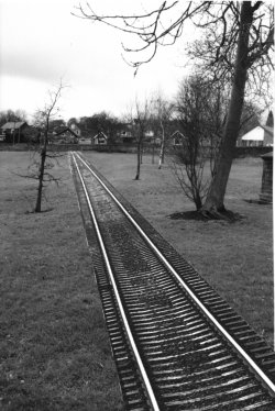
The tramway followed a route from Oldknow's Lime Kilns, across what is now the Recreation Ground and proceeded roughly along the present day St. Martin's Road. It then turned and crossed the route of the canal just below lock 10, near the Tollgate Cottage, before following the towpath as far as Station Road. Beyond this point the route is uncertain but is likely to have followed a path similar to the current roadway to the Aqueduct on the opposite side of the canal to the towpath.
The Canal Company's financial problems were eventually resolved in 1803 after Richard Arkwright made a loan of Ł24,000, only Ł3,000 less than the full cost of the locks. Construction was undertaken by contractors James and Fox and work was finally completed in late 1805, although the first passage through them is said to have been made following completion of Posset Bridge in 1804 by Oldknow, in his boat "Perseverance". Traffic was so great during this time that the tramway continued in use for another two years after completion of the locks and was not dismantled until 1807.
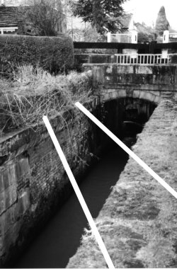
Hardly a trace of the tramway remains visible today, although the banking across the Recreation Ground between Strines Road and Oldknow Road can still be made out near the children's play area. The only other remaining evidence is very hard to spot unless you know exactly where to look. Below lock 10, just past the steps that gave the boatmen access to Tollgate Cottage, you can still see the grooves in the stonework where the track once cut diagonally across the canal.
Feed Back Article accompanying this item in the paper.
![]()
| Marple Tramway |
|
|
|
This article, by Mark Whittaker, appeared in the March 2001 issue of the Community News in our regular feature "Local History & Heritage with the Marple Website" Unfortunately in the setting out in the paper the photo captions got mixed up with the main text, making it a little disjointed. This is the way it should have appeared. The feed-back article that accompanied this is on a separate page. |