Dig
Index![]()
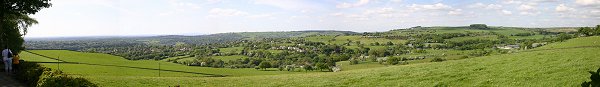
| Mellor Old Vicarage Dig - Open Days 2004 |
Dig
Index |
REPORT ON THE 2004 SEASON OF
EXCAVATION AT MELLOR
Extracts from report by University of
Manchester Field Archaeology Centre (Jan 2005)
Click here for Proposals for the 2005 Season of Excavation at Mellor
(click here to open a new window with a larger map of the areas described in this report)
3. 2004 Excavation Results
3.1 Aims and Objectives
The archaeological excavations at Mellor are designed as an evaluation programme to try and answer some fundamental questions about the site, its age, size and nature of the settlement on the hill top. The excavation has the full support of the county archaeology curators, the Greater Manchester Archaeological Unit (GMAU). The Trust, UMAU and GMAU cooperate closely in the development and implementation of the excavation strategy at Mellor.
Each year the results from previous seasons are assessed and a plan of excavation developed for the next season. In 2004 it was decided to excavate seven trenches each located to try and answer specific questions raised by excavation in previous years:-
Trench 26 was excavated to provide more evidence on the alignment of the ditch found in Trench 18 and to investigate the nature and extent of the curving gully identified within the 2003 trial trenches in Area C.
Trench 27 was excavated to expose the enclosure ditch as close as possible to the north wall of the Old Vicarage were it formed a boundary between Area A and Area B. There is a discrepancy in height between the two areas at this point with Area A to the south of the wall being some eight feet higher than Area B immediately to the north. It was hoped to discover if this was a result of human activity as had been seen in Trench 25 at the west end of Area A.
Trench 28 and Trench 29 were designed to examine the level of archaeological survival in the north and west of Area C.
Trench 30 was excavated to investigate a linear anomaly identified by geophysical survey within Area E.
Trench 31 and Trench 32 were excavated adjacent to Trench 18 to confirm the presence of a palisade slot and locate any further extent of the large ditch found in Trench 18.
Trial trench 16 ran south east to north west in Area B, close to and parallel with the boundary wall separating Area B from Area A. Its purpose was to look for indications that the defensive ditch might loop into Area B before turning south west into Area A before joining Trench 1. It would also provide a chance to assess the level of archaeological survival in the part of Area A which lies inside the enclosure ditch. The difference between the trial trench and the other trenches is that it was never the intention to carry out any excavation in the trial trench. The methodology is simply to strip away the topsoil and subsoil and then observe and record what is revealed.
3.2 Results
3.2.1 Trench 26
Trench 26 was designed to provide information about the alignment of the ditch represented in Trench 1 and Trench 18, specifically to see if the ditch continued north from Trench 18 into Area C. The resulting triangular trench measured 22m metres east west along the straight side and 26m along the hypotenuse and was 11m wide at its east end and 2.20m wide at its west end. The excavation showed some unexpected and surprising results. Trench 26 produced no indication of the large ditch. This suggests that it turns quite sharply from Trench 18 to run beneath the Old Vicarage drive towards Trench 1.The lack of the ditch was more than made up for by the abundance of pits, gullies and post holes that were visible cut into the natural boulder clay within the trench.
To the eastern end of the trench a series of overlapping circular gullies were identified and a number of sections were excavated to establish the stratigraphic relationships and dating of the various circles. In total there are the partial remains of at least ten gullies, seven of which appear to be parts of round house drainage gullies. As the gullies are overlapping it is apparent that there is more than one phase to their excavation. This is fairly typical of drainage gullies which have to be cleaned out, re- cut or re-aligned on a regular basis in order to keep them working efficiently. No dateable artefacts were recovered from the gullies themselves but a number of samples of charcoal were taken from which it may be possible to obtain radiocarbon dates. It seems clear that the excavation of Trench 26 has revealed the location of a second round house on the hilltop at Mellor.
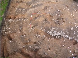
Figure 2: Overhead view of the round house gullies within Trench
26.
In the north west corner of the trench a short length of two curving and overlapping gullies were identified which possibly indicate the position of a third roundhouse. In between this area and that of the multiple gullies mentioned above, is an area characterised by a distinctive lack of gullies, but possessing an abundance of assorted postholes. The majority of the postholes within this area are characterised by being small and circular, in nature and highly packed with angular stones.
To the far western end of the trench a series of inter-cutting pits had been cut through the round house gullies. The pits are irregular in size and shape, and appear to spread in a north easterly direction. The excavated sections across the pits produced a small amount of Roman pottery, and a vast quantity charcoal, which was sampled with the hope of being able to have it radiocarbon dated.
In order to ensure that Trench 26 had not just missed the large ditch a 6.0m eastern extension was excavated. Again there was no indication of the ditch but the extension did reveal more pits. A beautiful Bronze Age flint dagger was found during the excavation of the extension. This type of artefact is rare and is sometimes found in association with a burial. The dagger will be analysed by a specialist, but early indications show the dagger to be of regional importance. No archaeological features within the trench extension were excavated and a sheet of durable plastic was put down prior to it being backfilled in order to delineate the archaeological levels and protect the features for future investigation.
3.2.2 Trench 27
Trench measured 5.2 metres long and 14 metres in length in a north south orientation following the gradual slope up within Area B towards the boundary wall with Area A. Upon removal of the topsoil and subsoil, natural bedrock was encountered almost immediately. Cut into the bedrock the outer enclosure ditch ran the length of the trench. At the north end of the trench it was 1.75 metres wide and 1.09 metres deep. These dimensions are very similar to its dimensions revealed in other trenches to the north and east in Area B. As it ran south in Trench 27 it became shallower and narrower. At the south end of the trench it measured 0.60m wide by 0.30m deep. This might indicate that the ditch in the southern half of Trench 26 has had the top 0.50m truncated. It is possible that this was because a segment of the slope in Area B has been excavated and levelled off. The excavated material could have been used to level up the slope within Area A and the boundary wall built to retain the levelling material and formalise the terrace. This would fit in with the evidence from Trench 25 of a deliberate landscaping programme to create a level garden on the east and north side of the Old Vicarage.
No artefacts were recovered from the ditch itself; however a large quantity of post medieval pottery was recovered from the topsoil and the subsoil which could possibly be indicative of the owners of the Old Vicarage depositing their waste over the wall into the field. To the south of the trench there was an area which shows the continuation of the post medieval quarrying identified within Trench 17.
3.2.3 Trench 28
Trench 28 was a 5.5m square excavated to establish whether the high level of archaeological remains present within Trench 26 was the same in the west of Area C. During machine excavation of the subsoil a sherd of Roman samien ware was recovered. This lay just above the stratified archaeological deposits which were identified at a depth of 0.5m below the modern ground surface. The features were located primarily to the south of the trench and seemed to represent a number of irregular inter-cutting pits containing pale grey silty fills. They gave a clear indication that the high level of archaeological survival seen in Trench 26 extended to this part of Area C. The archaeological features were recorded, drawn and photographed. However due to adverse weather conditions it was decided not to excavate any of them. Trench 28 was lined with plastic to define the archaeological levels and then backfilled.
3.2.4 Trench 29
Trench 29 was established to see whether the high level of archaeological remains present within Trench 26 was the same in the north of Area C. The trench was approximately 4.0m square. A number of archaeological features were revealed within Trench 29 including what appear to be small pits and postholes. They gave a clear indication that the high level of archaeological survival seen in Trench 26 extended to this part of Area C. The archaeological features were recorded, drawn and photographed. However due to adverse weather conditions it was decided not to excavate any of them. Trench 29 was lined with plastic to define the archaeological levels and then backfilled.
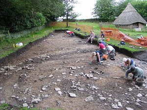
Figure 3: Volunteers at work cleaning the 2000 year old
remains of round
house gullies within sight of the reconstructed Iron Age round house.
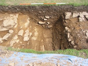
Figure 4: East facing section of the outer enclosure ditch within Trench 30.
3.2.5 Trench 30
Trench 30 was placed over a North West - South East linear anomaly identified during a geophysical survey of Area E. The trench 5m long and 2m wide showed that the anomaly was the result of human activity in the form of a ditch 1.65m wide and 0.83m deep similar in size and nature to the sections of outer enclosure ditch identified within the trenches excavated in Area B. At this stage any interpretation as to the date and function of this feature is highly speculative. However it is tempting to see it as part of the same Iron Age ditch system as the enclosure ditch in Area A.
3.2.6 Trench 31
Trench 31 was designed to seek confirmation as to whether or not the short stretch of stone lined gully found in Trench 18 in 2003 is associated with the large defensive ditch. Although the gully and ditch did run parallel to each other in Trench 18 only a relatively short stretch was revealed and the possibility existed that their proximity was just a coincidence.
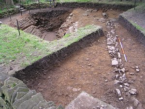
Figure 5: The palisade slot and the inner enclosure ditch located within trenches 18 and 32.
3.2.7 Trench 32
Trench 32 was excavated 4m to the south of Trench 18. Its purpose was to confirm the suspected southern alignment of the large ditch within Area A. Trench 32 measured 8.10m in length and was 1m wide. No excavation was carried out in this trench as once the topsoil and subsoil had been removed the fill of the ditch stood out against the natural fractured bedrock clearly showing its alignment. Also visible in Trench 32 was the palisade gully again running parallel with the ditch. Trench 32 showed the ditch continuing along the same alignment as identified within Trench 18. A projection of this line would take it through the wooded area of the Old Vicarage Garden into the graveyard of St. Thomas's Church.
3.2.8 Trial Trench 16
Trial Trench 16 was 1.7m wide and ran south east to north west for 55m from the gate joining Area B to Area C. Its western terminus was designed to be the point where it located the enclosure ditch
The south east half of Trial trench 16 revealed the layer of natural boulder clay. A small irregular pit and two small postholes were identified against the boulder clay. The north west half of the Trial trench revealed the natural bedrock. No archaeological features were identified in this half other than the enclosure ditch. This part of the Trial trench was then expanded north and south to form Trench 27. Pottery from the 18th and 19th centuries was recovered during topsoil and subsoil removal. The quantity of pottery increased notably towards the north west end of the trench.
3.2.9 Geophysics
A geophysical survey using ground penetrating radar was commissioned and carried out during the Open weekend of the 4th and 5th of September 2004. The survey area consisted of the driveway to the Old Vicarage, part of the area between the driveway and Trench 1, and the area directly in between Trench 18 and Trench 32. The results show an anomaly underneath the driveway could represent the large ditch if it curves round from Trench 18 and runs beneath the driveway towards the Old Vicarage and Trench 1.
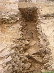
Figure 6: North facing section of the outer enclosure ditch, located in Trench 27.
4. Discussion
The discoveries resulting from the 2004 season of archaeological works as usual produced not only many answers but new questions. Excavation suggests that the large inner ditch does not continue far north from Trench 18 and most likely turns to run west towards the Old Vicarage to join Trench 1. The stone lined gully found in Trench 31 and Trench would seem to confirm that on the inside of the ditch there would have been a rampart or palisade. It is tempting to suggest that this defensive arrangement would have run along what is now the Old Vicarage driveway, turned south to join the ditch in Trench 1. Previous excavation has located the ditch and palisade gully running out of the south west corner of the Old Vicarage garden. From there it may well swing round to run east following the line of what is now the south wall of the churchyard before turning north through the churchyard to rejoin Trench 18.
At the end of 2003, with the discovery of the round house gully in Area A and the possibility that this area lay within part of the hilltop defended by a substantial ditch and palisade, it was thought that this might represent the limit of the zone of human occupation during the Iron Age at Mellor. This theory would have people living within the defended area with the zone between the defensive ditch and the enclosure being used for agricultural purposes. However if the suggestion that the defensive ditch runs along the line of the Old Vicarage driveway is correct then the round house gullies found in Trench 26 in 2004 clearly indicate occupation outside of the defended area.
The nature of the round house gullies identified at the east end of Trench 26 probably indicates use and re-use of the same area for a single round house suggesting a long occupation of the same piece of land for domestic dwellings. Moving west along Trench 26 there is a 13m long area devoid of curving gullies with the possibility that this type of feature reappears in the north west corner of the Trench. This pattern was seen in Trench 16 excavated in 2002 where the curving gullies of the round house occupied only the west half of the trench the east half being occupied with a number of pits and post holes. Together the evidence from Trench 26 and Trench 16 seems to indicate that particular zones within the settlement are dedicated to housing and that there are areas in between these that are allocated to other uses. The potential uses of these spaces are unknown, but must use significant numbers of wooden posts as shown in Trench 26. Pending radiocarbon results there is as yet no absolute dating evidence for the gullies in Trench 26. Radiocarbon dating suggests an Iron Age date for the round house gullies in Trench 16. However, given the amount of 1st to 2nd century AD pottery from nearby Trench 18, that the gullies in Trench 26 represent evidence of Romano-British occupation of the hilltop.
Trenches 28 and 29 support the theory of an expanded zone of settlement indicating that the level of archaeological activity seen in Trench 26 continues north and west in Area C.
The evidence from Trench 27 excavated over the enclosure ditch seems to support the theory that the hilltop at the west end of Area A has been extensively landscaped. It would seem that the natural slope of the hill between Area A and Area B would have followed a line drawn between the natural bedrock at the side of the ditch in Trench 1 to the natural bedrock approximately half way along Trench 27, at the side of the enclosure ditch.
The discovery of the ditch in Trench 30 was very exciting and it is tempting to associate it with the enclosure ditch in Area B. If it is part of the same Iron Age ditch system it would mean that nearly all the hill at Mellor is enclosed. This would have significant implications on the role that Mellor played within the Iron Age society in the region. However it is too early to draw any firm conclusions regarding the date and function of this ditch.
|
The pottery types and radiocarbon dates from Mellor have become bench marks for assessing other Iron Age sites in the region. Over 100 sherds of Iron Age pottery from a single vessel have now been conserved and put together to produce the 'Mellor Pot'. The Iron Age finds from Mellor prompted Dr Chris Cumberpatch, the excavation's archaeological consultant on prehistoric pottery, to write 'A recent review of the Iron Age in Britain has described Derbyshire and Lancashire as a 'black hole' and this makes the site at Mellor of considerable regional, even national importance'. The specialist report on the Roman pottery from Trench 18 has also raised expectations about the character of the settlement at Mellor during the Roman period. 'The vessel types indicate a high status site. The Mellor assemblage compares with urban and villa sites rather than rural sites on the basis of its jar to bowl ratio. This conclusion is supported by the range of traded wares present'. |
Archaeological Background: 1995-2003
Ann Hearle, Chair of Marple Local History Society and Dr Peter Arrowsmith of the University of Manchester Archaeological Unit (UMAU) first suggested the presence of an Iron Age Hill fort at Mellor in 1998. The suggestion was based on a photograph taken by Ann Hearle of the field to the north of her house at the Old Vicarage during the summer of 1995. The majority of the grass in the field had been bleached brown by the sun. However the photograph showed a line of lush grass arcing across the field. It was felt that the line might be following that of a filled in ditch. The less compact nature of the in fill of the ditch would retain water and so better sustain the grass above it in times of drought.
The next step was a geophysical survey which confirmed the presence of a below ground anomaly corresponding to the line of grass in the field (Area B) and others in the garden of the Old Vicarage itself (Area A). Excavation started in the summer of 1998. Trench 1 was excavated over one of the anomalies at the west end of the garden. This revealed a large ditch cut into the sandstone bedrock. This section of ditch was over 4m wide and 2.10m deep. The top fills of this contained fragment of Roman tile, pottery and glass. Lower down the fills contained pottery and other artefacts dating from the Iron Age. The high charcoal content of one of these fills near the base of the ditch meant that a sample could be taken for radiocarbon analysis. This produced a date of 430 BC + or - 140 years.
During November 2002 Trench 25 was excavated through part of the vegetable patch adjacent to the ditch in Trench 1. This 12m long trench showed that the current flat ground surface is a result of deliberate levelling of the natural slope of the hill in post medieval times. The implications of this are that the ditch found in Trench 1 would have been situated upon the break of a steep slope and would have been highly effective defensively, and far more visible and imposing nature within the ancient landscape.
In 2002 and 2003 Trench 18, was excavated over an anomaly at the opposite end of Area A. This revealed a section of ditch very similar to that found in Trench 1. This section of ditch ran north to south and measured just over 4.0m wide and 1.90m deep. Within the ditch an abundance of artefacts were recovered dating from the 1st to the 4th century AD. These included 5 bronze Roman Brooches, 221 sherds of Romano-British Pottery and fragments of quern stones. Most of these finds came from the upper fills and in some cases pottery from several different centuries was recovered from the same soil context. This would suggest that the a disused and already partly silted up Iron Age ditch was used as dumping ground when the Roman occupation of the site ended in the 4th Century AD. It seems likely that the sections in Trench 1 and Trench 18 are part of the same ditch. This interpretation means that in the Iron Age the area of the Old Vicarage and Saint Thomas' church were surrounded by an imposing defensive ditch.
Immediately to the west of the ditch and contained within the same trench, a small stone filled slot was identified running parallel to the ditch. It was thought that this might be the foundations for a palisade running inside the ditch. However too short a length was exposed to be certain of this interpretation.
Two trial trenches were excavated on the other side of the Old Vicarage drive, immediately opposite Trench 18, in Area C. These were intended to look for the ditch found in Trench 18 continuing into this area. The evidence for the ditch was unclear but one of the trial trenches seemed to suggest the presence of a curving gully perhaps associated with a round house.
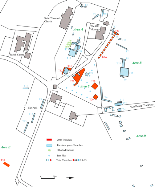
Figure 1: Plan showing the location of the trenches excavated at Mellor to date.
Click for larger map
Trenches have also been excavated over an anomaly in Area B to the north of the Old Vicarage. These have revealed a c400m stretch of an Iron Age ditch running southwest to northeast. The ditch in this field is around 2m wide and about 1.70m deep and probably represents an Iron Age enclosure ditch defining the limits of the settlement at Mellor. The 2001 excavation on this section of ditch produced 125 sherds of pottery belonging to the same Iron Age pot. These have now been conserved and the pot reconstructed.
Excavation has so far concentrated on defining the extent of this ditch to the north and west of the Old Vicarage. In November 2002 a geophysical survey using a magnetometer was carried out in Area D to look for indications of an eastern arm of the ditch. On the basis of the survey results two trial trenches were excavated which failed to find any evidence for the ditch. Further geophysical analysis in the run up to the 2003 season led to the excavation of two trenches and eleven trial trenches designed to determine the line of this enclosure ditch beyond Area B. Results seem to show that this enclosure ditch does not turn back towards the church but carries straight on towards Mellor Old Hall. This implies that the ditch encloses an area of land far greater than previously anticipated and dramatically increases the potential size of the Iron Age settlement.
Palaeoenvironmental analysis of the archaeological fills within the enclosure ditch indicated the presence of mixed deciduous woodland, a nearby open body of water and an associated wet meadow, contemporary with when the ditch was open. The recovery of cereal-type pollens indicates the presence of a mixed farming economy.
The archaeology within the ditches has not been neglected. In 1999 Trench 3 was opened up in the centre of Area A. In the eastern half of this trench the sandstone bedrock was covered by a layer of boulder clay. Cut into this layer was a complex pattern of postholes, ditches and gullies ranging in date from the Mesolithic period 5 to 10,000 years ago through to the Roman period. In 2002 a 10m square, Trench 16 was opened adjacent to Trench 3. Amongst the features found in Trench 16 were a series of gullies, which formed an arc within the west half of the trench. The results from this trench allowed a fuller interpretation of the features from Trench 3 to be made. This suggested that the curving gullies continued beyond the boundaries of Trench 16 presenting the possibility that they would form a complete circle typical of the drainage gullies found outside Iron Age round houses. Radio Carbon dates from charcoal taken from the fill of these gullies gave a date of between 380 BC and 520 BC. Finds from Trench 16 included a polished flint chisel of a style associated with the Late Neolithic Period. C2-3,000 BC.
The excavation of trenches 21 and 23 in 2003 confirmed the presence of an Iron Age round house. Combining the results from several years of excavation produces a circular drainage gully for a round house with a diameter of approximately 13 metres. No Iron Age finds were recovered from the sections of the gully excavated in 2003. However from the gully and the area immediately to the north 97 flint flakes were recovered. Specialist analysis shows these to be characteristic of the Mesolithic Period and indicative of hunter-gatherer communities using the hilltop at Mellor as one of their seasonal bases over 10,000 years ago.