Dig
Index![]()
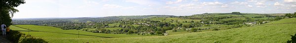
| Mellor Old Vicarage Dig - Open Days 2003 |
Dig
Index |
REPORT ON THE 2003 SEASON OF
EXCAVATION AT MELLOR
Extracts from report by University of
Manchester Field Archaeology Centre (Jan 2004)
Click here for Proposals for the 2005 Season of Excavation at Mellor
(click here to open a new window with a larger map of the areas described in this report)
2. 2003 Excavations
2.1 Aims and Objectives
The archaeological excavation at Mellor is designed as an evaluation programme to try and answer some fundamental questions about the site, its age, size and nature of the settlement on the hilltop. Each year the results from previous excavations are assessed and a plan of excavation developed for the next season. In 2003 it was decided that our objectives would be: -
To expand Trench 18 to determine the nature of the archaeological feature found in 2002.
To follow the line of the gullies found in Trench 16 to see if they do form a circle.
To locate by excavation the position of the ditch at the extreme eastern end of Area B and from that to try and pick up its line in the walled 'Ale House' track way immediately east of Area B.
2.2 Trench 18
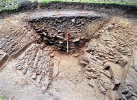 An area roughly 9m by 7m to the
south and east of the 2002 excavation was stripped of topsoil. This revealed a
dark grey band of soil running northwest to southeast. This material stood out
against the orange brown colour of the natural sandstone bedrock. Excavation of
this material and the similar grey layer directly below it proved that we had
found both sides of a substantial ditch. Several other layers were excavated
before the full extent of the ditch was revealed. Cut into the natural sandstone
bedrock the ditch was between 4m and 5.50m wide and on average 2.00m deep.
Running parallel to the west side of the ditch was a narrow stone lined gully.
The gully was 1.40m away from the edge of the ditch. This may represent a slot
cut to take a wooden palisade, which, along with the ditch itself, would have
provided a formidable defensive arrangement. Two trial trenches were stripped of
topsoil in Area C to see if there was any indication of the ditch curving west
towards the Old Vicarage. A large spread of stones was revealed which may
represent the top fill of the ditch as well as part of what might be the curving
gully of a second round house.
An area roughly 9m by 7m to the
south and east of the 2002 excavation was stripped of topsoil. This revealed a
dark grey band of soil running northwest to southeast. This material stood out
against the orange brown colour of the natural sandstone bedrock. Excavation of
this material and the similar grey layer directly below it proved that we had
found both sides of a substantial ditch. Several other layers were excavated
before the full extent of the ditch was revealed. Cut into the natural sandstone
bedrock the ditch was between 4m and 5.50m wide and on average 2.00m deep.
Running parallel to the west side of the ditch was a narrow stone lined gully.
The gully was 1.40m away from the edge of the ditch. This may represent a slot
cut to take a wooden palisade, which, along with the ditch itself, would have
provided a formidable defensive arrangement. Two trial trenches were stripped of
topsoil in Area C to see if there was any indication of the ditch curving west
towards the Old Vicarage. A large spread of stones was revealed which may
represent the top fill of the ditch as well as part of what might be the curving
gully of a second round house.
In total a 5m stretch of the ditch was excavated which produced an abundance of finds. These included fragments of quern stones used to grind corn, the remains of 5 bronze Roman brooches and 221 sherds of Romano-British pottery along with around 40 scraps of briquetage, a type of pottery used in the salt trade. The vast majority came from the top 2 fílls of the ditch, which seem to represent a deliberate back filling at the time the site was abandoned. As in previous years the excavations produced a wide range of wares coming from distant sources including Dorset, Mancetter-Hartshill, the Severn Valley kilns to the south, the Cheshire Plains kilns, Derbyshire kilns around Belper, Lincolnshire kilns and mortaria, perhaps from Wilderspool. The vessel types indicate a date range from the late first century AD to the mid third century at least.
2.3 Trenches 21 and 23
 These trenches were designed
specifically to follow the line of the gullies found previously in Trenches 3
and 16. Trench 23 covered the short stretch between the southwest comer of
Trench 16 and one of the picturesque rhododendron bushes that inhabit the
beautiful garden of the Old Vicarage and which are, understandably out of bounds
for excavation. In this Trench the dark grey fill of one of the gullies could be
clearly followed running south east between Trench 16 and the rhododendron bush.
One of the finds in Trench 23 was a large stone with grooves and a notch worked
into it, which has many similarities with prehistoric hammer stones found at
other sites. Trench 21 formed an 'L' shape to try to follow the gully on what
would be the north and east sides of a roundhouse. The arm, which ran east to
west, was excavated immediately to the north of Trenches 3 and 16. Here again
the distinctive dark grey fill of the gullies were relatively easy to follow as
they ran into the east end of the trench and then arced round to run south
exactly as would be expected of a roundhouse gully.
These trenches were designed
specifically to follow the line of the gullies found previously in Trenches 3
and 16. Trench 23 covered the short stretch between the southwest comer of
Trench 16 and one of the picturesque rhododendron bushes that inhabit the
beautiful garden of the Old Vicarage and which are, understandably out of bounds
for excavation. In this Trench the dark grey fill of one of the gullies could be
clearly followed running south east between Trench 16 and the rhododendron bush.
One of the finds in Trench 23 was a large stone with grooves and a notch worked
into it, which has many similarities with prehistoric hammer stones found at
other sites. Trench 21 formed an 'L' shape to try to follow the gully on what
would be the north and east sides of a roundhouse. The arm, which ran east to
west, was excavated immediately to the north of Trenches 3 and 16. Here again
the distinctive dark grey fill of the gullies were relatively easy to follow as
they ran into the east end of the trench and then arced round to run south
exactly as would be expected of a roundhouse gully.
So far the natural material through which the gullies were cut had been a layer of orange brown boulder clay. This would have been easy material through which to originally dig the gullies and from an archaeological perspective the dark grey, charcoal rich fills of the gullies had been easy to spot against the boulder clay. However as the gullies turned to run south two things happened. The boulder clay was replaced by natural sandstone bedrock and the charcoal content of the gully fills dropped dramatically. Despite this it was still possible to follow a line were parts of the plated bedrock had been levered out to form a shallow channel. This situation persisted for around 6m until the gully curved again to run southeast. As it got closer to Trench 23 the boulder clay reappeared and the charcoal content increased. By the time Trench 21 reached the rhododendron bush the gullies described an almost perfect horseshoe shape around 13m in diameter. Even without linking Trenches 21 and 23 it is now fairly certain that these gullies represent the drainage system around an Iron Age round house.
There were no Iron Age finds from the sections, which were excavated through the gullies. However several flint flakes were recovered. In a 4m square northern extension to Trench 21 an area of highly eroded natural sandstone bedrock was revealed. From the top of this layer over 50 flint flakes were recovered which along with those from the gully fills and from the topsoil and subsoil gave a total of 97 all from a c5m square. In addition this area was close to the west end of Trench 3 were a number of flint flakes had been found during the 1999 and 2000 excavations. These had been analysed by a specialist and identified as being characteristic of the Mesolithic period. It seems highly likely that the flakes found in 2003 will be of a similar date proving conclusively that hunter-gatherer communities were using the hilltop at Mellor as one of their seasonal bases 10,000 years ago.
2.4 Trenches 22 and 24
 Trench 22 was planned as part
of a campaign to trace the east arm of the enclosure. It was an 11m by 4m trench
designed to locate the ditch as far to the east as possible in Area B. This
would then serve as a guide for a series of trenches further east between the
walls of the 'Ale House' track way. These trenches would have the topsoil and
subsoil excavated by machine with the purpose of seeing if the ditch continued
east or if it turned south to run up the track-way towards the Old Vicarage
garden and Trench 18. The excavation in this area was only possible thanks to
permission from Stockport Borough Councils Footpaths Officer.
Trench 22 was planned as part
of a campaign to trace the east arm of the enclosure. It was an 11m by 4m trench
designed to locate the ditch as far to the east as possible in Area B. This
would then serve as a guide for a series of trenches further east between the
walls of the 'Ale House' track way. These trenches would have the topsoil and
subsoil excavated by machine with the purpose of seeing if the ditch continued
east or if it turned south to run up the track-way towards the Old Vicarage
garden and Trench 18. The excavation in this area was only possible thanks to
permission from Stockport Borough Councils Footpaths Officer.
Topsoil and subsoil stripping on Trench 21 was done by machine and revealed the natural boulder clay. The vast majority of the trenches in Area B had been dug on the sandstone, however the closest previous trench to Trench 21 had also revealed boulder clay. This in itself was interesting as along with evidence from the trenches in the Old Vicarage garden and Area C it shows that there is a band of boulder clay running down the hillside. This is important, as the level of survival of archaeological features seems to be greater within the area of boulder clay. Within Trench 21 it was possible to detect the fill of the enclosure ditch running west to east as far as the west wall of the track-way. Excavation of the ditch showed it to be 1.90m wide and 1.10m deep, very similar dimensions to ditch sections excavated elsewhere in Area B.
The next step was to topsoil strip four trenches between the walls of the track-way. These showed no evidence of the ditch turning north. However in one of them, Trench 24, the fill of the ditch could be clearly seen following the same west to east alignment as in Trench 22. While it was gratifying to locate the ditch in this area it did pose the question were does the ditch turn south back towards the top of the hill? The trial trenches excavated in November 2002 found no evidence of an eastern arm in the field to the east of Area B and now the track-way had been eliminated as the point were the ditch turned. By a happy coincidence the 2003 excavations coincided with the owner ploughing the field to the east of Area B prior to re-seeding. He good enough to give us permission to topsoil strip a series of 1.5m wide trenches in this field to look for signs of the ditch. The first trial trench was excavated across a projected easterly extension of the ditch found in Trench 24. This trench revealed a clear band of mid brown silt running west to east, which also appeared in the eight subsequent trial trenches, which were topsoil stripped in this field. If this interpretation is correct then the enclosure ditch runs east for at least a further 120m beyond Area B. Although the feature that this material filled was not excavated it seems very likely that it represents a continuation of the enclosure ditch. In one of the trenches the brown silt was seen to come to an end only to start again in the next trench opened 2m further east. This would seem to represent an entranceway through the enclosure ditch.
2.5 Trench 25
In November 2003 John and Ann Hearle gave permission for a trench to be excavated in their garden close to Trench 1. Trench 25 was 1.5m wide and ran east to west for 12m. The specific purpose of this trench was to see if any evidence could be found for the enclosure ditch running through this part of their garden as a second, outer ditch, to the one found in Trench 1. Although no evidence for an outer ditch was found the trench provided valuable information about the topography of the west end of the hill. What Trench 25 showed was that the almost perfectly flat garden of today is a result of substantial landscaping. At the east end of the trench the depth of the topsoil and subsoil was 0.50m. This was a similar depth to that found in other trenches within the garden. However it was found that the natural bedrock sloped away so much that at the west end of the trench the topsoil and subsoil was 1.20m deep. This tells us a lot about how the settlement at Mellor sat within its Iron Age landscape. Rather than running across a flat piece of hilltop set back from the slope of the hill the ditch and possibly a palisade would have run right along the contour line of the break of the slope. This would have made the defences of the hilltop a much more visible statement of ownership to anyone approaching the settlement.
3. Discussion
The discoveries made in 2003 open up several new and fascinating possibilities for the site at Mellor. In terms of its dimensions and the nature of its fills the ditch in Trench 18 is far more like the section of ditch found in Trench 1 than those found in trenches in Area B. We must now ask ourselves whether there were 2 ditches surrounding the hilltop at Mellor? Perhaps the ditch found in the trenches in Area B and to the east represents an extensive but not primarily defensive enclosure ditch. Last year's work suggests that it may well have encompassed most of the hill. The purpose of this ditch would be to clearly mark out the property boundary of the people who lived at Mellor in the Iron Age. In addition it could be used to delineate particular areas of land use, crops, cattle, industry etc. If the ditches found in Trenches 1 and 18 are the same these may represent a less extensive but more substantial, defensive, system perhaps with an associated palisade. Given that there seems to be an Iron Age round house almost exactly between Trenches 1 and 18 it may be that this ditch enclosed the area of habitation on the hilltop. A second possibility is that there are 2 ditches, but they are not contemporary. The smaller ditch may represent occupation during a relatively peaceful time when it was not felt necessary to have substantial defences while the larger ditch may represent occupation at a time when land and resources had to be defended.
1. Background: 1995-2002
Ann Hearle, Chair of Marple Local History Society and Dr Peter Arrowsmith of the University of Manchester Archaeological Unit (UMAU) first suggested the presence of an Iron Age Hillfort at Mellor in 1998. The suggestion was based on a photograph taken by Ann Hearle of the field to the north of her house at the Old Vicarage during the summer of 1995. The majority of the grass in the field had been bleached brown by the sun. However the photograph showed a line of lush grass arcing across the field. It was felt that the line might be following that of a filled in ditch. The less compact nature of the in fill of the ditch would retain water and so better sustain the grass above it in times of drought.
The next step was a geophysical survey which confirmed the presence of a below ground anomaly corresponding to the line of grass in the field (Area B) and others in the garden of the Old Vicarage itself (Area A). Excavation started in the summer of 1998. Trench 1 over one of the anomalies in the garden revealed a large ditch cut into the sandstone bedrock. In places this section of ditch was over 4m wide and 2.10m deep. The top fills of this ditch contained fragments of Roman tile, pottery and glass. Lower down the fílls contained pottery and other artefacts dating from the Iron Age. The high charcoal content of one of these fills near the base of the ditch meant that a sample could be taken for radiocarbon analysis. This sample produced a date of 430 BC + or - 140 years. In 2002 an evaluation trench, Trench 18, was excavated over an anomaly detected by a geophysical survey at the east end of the Old Vicarage garden. This revealed the west side of a wide, deep archaeological feature cut into the sandstone bedrock, which because of the size of the trench could not be fully excavated and interpreted. However one possibility was that it might be part of a large ditch.
Trenches have also been excavated over the anomaly in the field to the north of the Old Vicarage. These have revealed a c400m stretch of an Iron Age ditch running southwest to northeast. The ditch in this field is around 2m wide and about 1.70m deep. The 2001 excavation on this section of ditch produced 125 sherds of pottery belonging to the same Iron Age pot. These have now been conserved and the pot reconstructed. Excavation has so far concentrated on defining the extent of this ditch to the north and west of the Old Vicarage. In November 2002 a geophysical survey using a magnetometer was carried out in the field to the south east of Area B to look for indications of an eastern arm of the ditch. On the basis of the survey results two trial trenches were excavated which failed to find any evidence for the ditch.
The archaeology within the area enclosed by the ditch has not been neglected. In 1999 Trench 3 was opened up in the centre of the Old Vicarage garden. In the eastern half of this trench the sandstone bedrock was covered by a layer of boulder clay. Cut into this layer was a complex pattern of postholes, ditches and gullies ranging in date from the Mesolithic period 5 to 10,000 years ago through to the Roman period. In 2002 a 10m square, Trench 16, was opened adjacent to Trench 3. Amongst the features found in Trench 16 were a series of gullies, which formed an arc within the west half of the trench. The results from this trench allowed a fuller interpretation of the features from Trench 3 to be made. This suggested that the curving gullies continued beyond the boundaries of Trench 16 presenting the possibility that they would form a complete circle typical of the drainage gullies found outside Iron Age round houses. Radio Carbon dates from charcoal taken from the fill of these gullies gave a date of between 380 BC and 520 BC. Finds from Trench 16 included a polished flint chisel of a style associated with the Late Neolithic Period. C2-3000 BC.
In 1999 the Mellor Archaeological Trust was set up to: -
Promote the investigation, interpretation and preservation of the archaeology of the area surrounding Mellor Church and of other parts of Mellor, Stockport, in the County of Greater Manchester.
Organise displays, educational activities, or other means of bringing information on the history and archaeology to the notice of the public.
The Trust has had great success in raising funds from Heritage Lottery grants and from revenue raised on open days and other events held during the year.
The excavations are carried out entirely by volunteers under the supervision of archaeologists from the University of Manchester Archaeological Unit. The excavation is a key part of UMAU's commitment to community archaeology in Greater Manchester. In 2003 this included working with Access Heritage and Stockport Parks on an excavation on Strines Farmhouse at Brinnington in Reddish Vale. The excavation allowed over 200 local school pupils to participate in an archaeological dig during the week. On the Saturday a 'Drop In' day attracted over 40 volunteers.