A M Photo-Graphics

Author Topic: Where "are" Rose Hill and Hawk Green?  (Read 2040 times)

0 Members and 1 Guest are viewing this topic.

royal_marple

  • Guest
Re: Where "are" Rose Hill and Hawk Green?
« Reply #8 on: March 31, 2021, 11:37:03 PM »
Rose Hill would be everything from Dan Bank up to the Railway line. This does exclude Rose Hill primary though. I'm not sure if seven stiles is rose hill, Norbury and the cricket club isn't!

I actually agree about Rose Hill Primary not actually being in Rose Hill, in fact apart from the two shops as well as Elmfield Drive, I wouldn't describe anything on that side of Stockport Rd as Rose Hill. Dale Road definitely isn't, but nor is Rose Hill Dental Practice which is much further down towards Dan Bank.

andy+kirsty

  • Guest
Re: Where "are" Rose Hill and Hawk Green?
« Reply #7 on: March 29, 2021, 04:10:40 PM »
I wonder whether the Half Green / Hawk Green changed at a similar time as the Hazel Grove re-brand? The Victorians did like to posh up names.

As someone who was born and still lives here i'd say that the modern boundary of Hawk Green is everything above the Peak Forest Canal and the Macc Canal. Rose Hill would be everything from Dan Bank up to the Railway line. This does exclude Rose Hill primary though. I'm not sure if seven stiles is rose hill, Norbury and the cricket club isn't!

I'm down on Wood Lane, which isn't Rose Hill, or Marple Proper - possibly Peace Field to those old enough, or 'MiddleWood View' if you were an estate agent

On a similar vein i've noticed signs for 'Little Moor' pop up in Offerton as people try and define an area or community. 

admin

  • Administrator
  • Hero Member
  • *****
  • Posts: 8421
    • The Marple Website
Re: Where "are" Rose Hill and Hawk Green?
« Reply #6 on: March 27, 2021, 05:50:09 PM »
This is an interesting question but I'm not sure there are definitive answers.

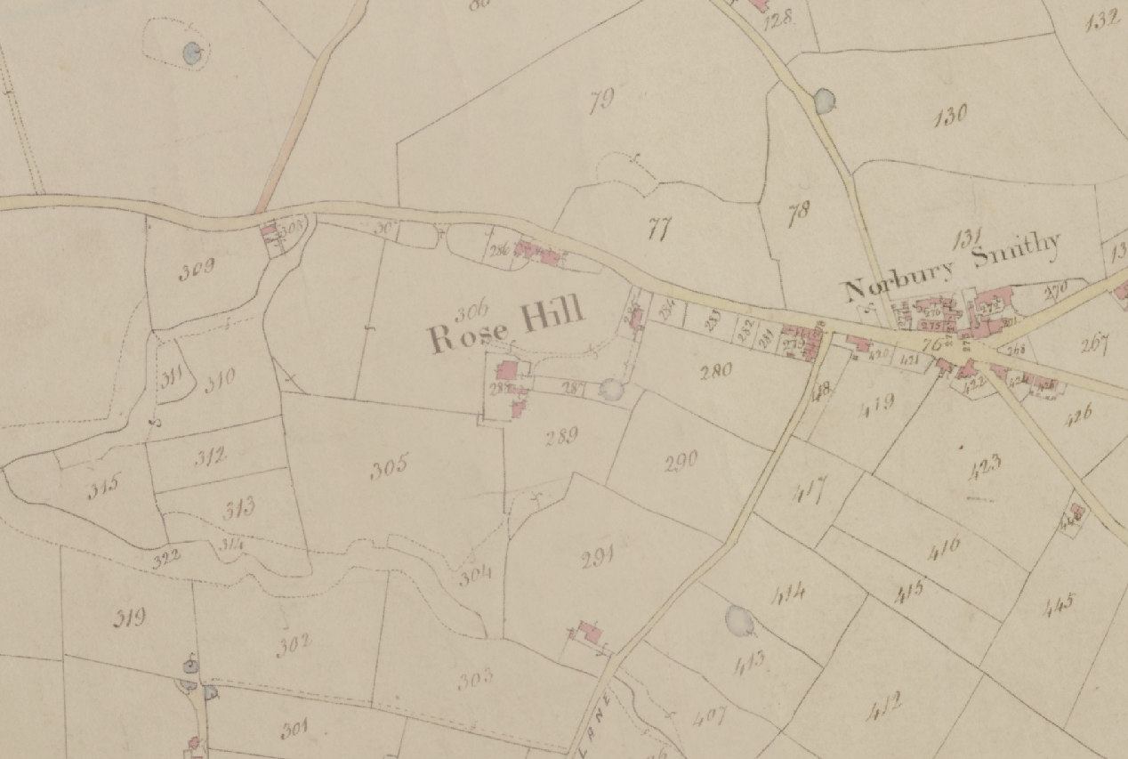
Rose Hill was originally just the area around Rose Hill House - see the tithe map from 1836-51 - when Rose Hill House and the old cottages on Stockport Road were all that was there. 

Going up Stockport Road towards Marple the next area was Norbury Smithy - around the Jolly Sailor pub (no longer there of course).

So Rose Hill has sort of grown up over time and the boundaries have blurred but looking at the early maps I would say the boundaries were loosely Cross Lane, Bowden Lane, Dark Lane (now Dale Road) and down to Throstle Grove.


Interestingly, Hawk Green isn't on the 1836-51 tithe map. Then it was called Half Green.


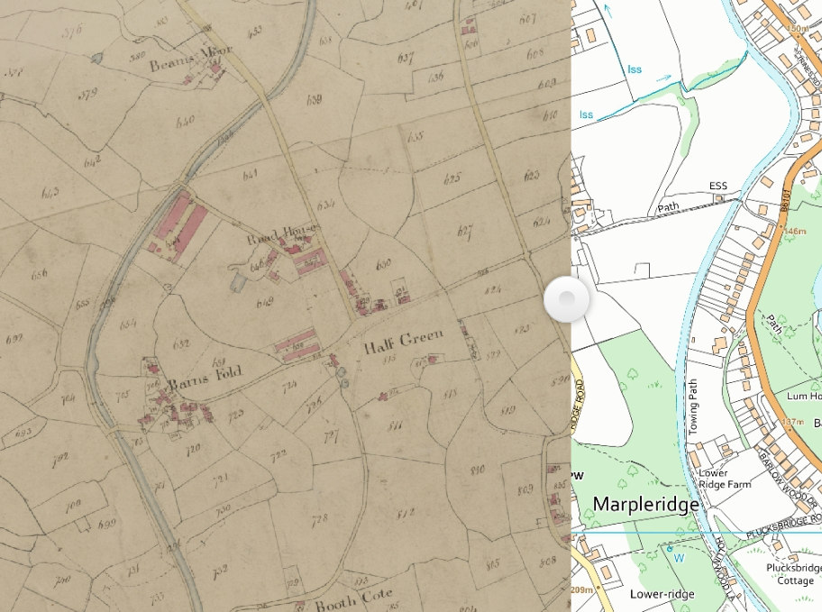
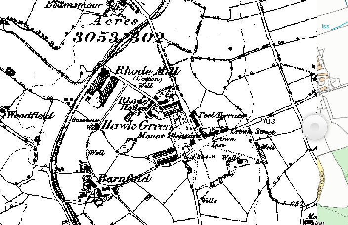
The name Hawk Green first appears on the 1875 OS maps, and then the boundaries looked pretty clear as there was so little development. I would say that the canal is the main hard boundary that remains and everything else has sprawled towards Church Lane, the Ridge and Windlehurst Road.


But these are just my thoughts. Have a look at the amazing resources provided by the Cheshire Tithe Maps and form your own views:

https://maps.cheshireeast.gov.uk/tithemaps/
Mark Whittaker
The Marple Website

amazon

  • Guest
Re: Where "are" Rose Hill and Hawk Green?
« Reply #5 on: March 27, 2021, 05:12:29 PM »
If you live there you will know,… I live close to Marple village.
Tell me

royal_marple

  • Guest
Re: Where "are" Rose Hill and Hawk Green?
« Reply #4 on: March 27, 2021, 04:03:46 PM »
If you live there you will know,… I live close to Marple village.

I lived in Rose Hill for 16 years but not sure where the area stops and starts.

Graham

  • Newbie
  • *
  • Posts: 32
Re: Where "are" Rose Hill and Hawk Green?
« Reply #3 on: March 27, 2021, 01:54:29 PM »
If you live there you will know,… I live close to Marple village.

amazon

  • Guest
Re: Where "are" Rose Hill and Hawk Green?
« Reply #2 on: March 27, 2021, 10:16:19 AM »
Rose Hill and Hawk Green are obviously two of the best-known areas of Marple, but is there an actual accepted definition of what roads are actually in these area?

For example, "Rose Hill" must include the entire Rose Hill estate, the area around the train station and primary school, even as far down as Rose Hill Dental Practice, but is Dale Road considered to be in Rose Hill? The Bowden Lane side of the school definitely isn't. What about the new housing estate where Rose Hill Brickworks once stood? How far towards Marple does Rose Hill end?

Likewise, is all of Marple on the Goyt Mill side of the canal considered to be Hawk Green?
Where does Ludworth end?

royal_marple

  • Guest
Where "are" Rose Hill and Hawk Green?
« Reply #1 on: March 27, 2021, 07:15:31 AM »
Rose Hill and Hawk Green are obviously two of the best-known areas of Marple, but is there an actual accepted definition of what roads are actually in these area?

For example, "Rose Hill" must include the entire Rose Hill estate, the area around the train station and primary school, even as far down as Rose Hill Dental Practice, but is Dale Road considered to be in Rose Hill? The Bowden Lane side of the school definitely isn't. What about the new housing estate where Rose Hill Brickworks once stood? How far towards Marple does Rose Hill end?

Likewise, is all of Marple on the Goyt Mill side of the canal considered to be Hawk Green?