
"Magnificent Mellor
Mapped"
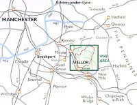
 One of Greater Manchester's
hidden gems is the beautiful parish of Mellor, nestling in the far south
eastern corner of Stockport and Marple. It rises from the valley of the
rushing River Goyt through fields and woods to wild moorland, reaching
over 1000 feet at the Derbyshire border close to the Peak District
National Park. Its rich variety of landscapes is matched by its
fascinating history, which has been traced back over thousands of years. One of Greater Manchester's
hidden gems is the beautiful parish of Mellor, nestling in the far south
eastern corner of Stockport and Marple. It rises from the valley of the
rushing River Goyt through fields and woods to wild moorland, reaching
over 1000 feet at the Derbyshire border close to the Peak District
National Park. Its rich variety of landscapes is matched by its
fascinating history, which has been traced back over thousands of years.
What Mellor has lacked is a
publication which brings together a wide range of key information about
this fascinating place.
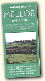
Until now, that is. Because
just published is a magnificent Walking Map of Mellor. It combines
beautiful and authoritative mapping of the whole area, at a scale ideal
for walkers and riders, with a range of photographs and a detailed
collection of historical notes on the various points of interest in the
district.
 The Walking Map of Mellor is
the brainchild of David Ackroyd and Peter Hewitt. David has lived in
Mellor for many years and is a keen walker and local historian. He
published (with a friend Geoff Heath) a book of 12 Mellor walks including
a 10Ẅ mile Mellor Boundary Walk. Peter worked years ago with David for
Stockport Council, and after he retired in 1999, they began to walk
together in the hills and valleys of Mellor. As they did so, they realised
the need for a map of the area which would provide all the information
walkers need to enrich their expeditions. The Walking Map of Mellor is
the brainchild of David Ackroyd and Peter Hewitt. David has lived in
Mellor for many years and is a keen walker and local historian. He
published (with a friend Geoff Heath) a book of 12 Mellor walks including
a 10Ẅ mile Mellor Boundary Walk. Peter worked years ago with David for
Stockport Council, and after he retired in 1999, they began to walk
together in the hills and valleys of Mellor. As they did so, they realised
the need for a map of the area which would provide all the information
walkers need to enrich their expeditions.
They resolved to fill that
gap, and the result of their collaboration is the Walking Map of Mellor,
already selling rapidly in the immediate area and now available to a wider
audience.
For more information and
how to order, visit http://www.mellormaps.co.uk
|